
- Start >
- Groundwater >
- Waterlevel of upper layer >
- Bayern >
- Mallersdorf Q6 >
- Chart of total period

Chart of total period Mallersdorf Q6
Groundwater levels of the total period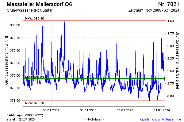
note
GW Messstelle im Grundnetz
Groundwater level [m above sealevel]: 379.14
Distance to surface [m]: 2.45
Last value from 07.03.2026 08:00
Ground level [m above sealevel]: 381.59
| Date | Groundwater level [m above sealevel] |
|---|---|
| 07.03.2026 | 379.14 |
| 06.03.2026 | 379.16 |
| 05.03.2026 | 379.18 |
| 04.03.2026 | 379.20 |
| 03.03.2026 | 379.22 |
| 02.03.2026 | 379.25 |
| 01.03.2026 | 379.27 |
| 28.02.2026 | 379.31 |
© Bayerisches Landesamt für Umwelt 2026