
- Start >
- Groundwater >
- Waterlevel of upper layer >
- Bayern >
- LICHTENAU 45.02 >
- Chart of total period

Chart of total period LICHTENAU 45.02
Groundwater levels of the total period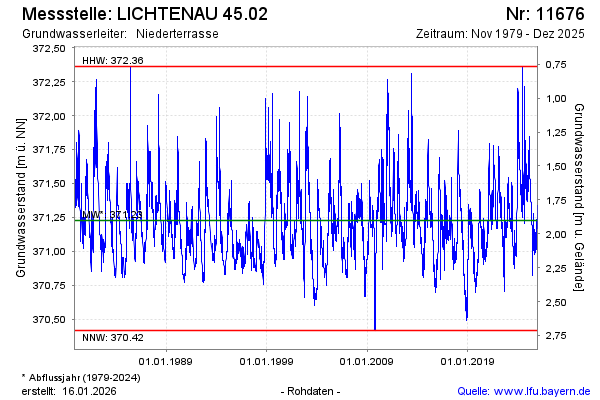
note
momentan keine Übertragung der Daten. Wird manuell ausgelesen
Groundwater level [m above sealevel]: 371.32
Distance to surface [m]: 1.81
Last value from 16.12.2025 10:00
Ground level [m above sealevel]: 373.13
| Date | Groundwater level [m above sealevel] |
|---|---|
| 16.12.2025 | 371.32 |
| 15.12.2025 | 371.33 |
| 14.12.2025 | 371.33 |
| 13.12.2025 | 371.33 |
| 12.12.2025 | 371.34 |
| 11.12.2025 | 371.34 |
| 10.12.2025 | 371.33 |
| 09.12.2025 | 371.33 |
© Bayerisches Landesamt für Umwelt 2026