
- Start >
- Groundwater >
- Waterlevel of upper layer >
- Bayern >
- KIRCHEHRENBACH 6 >
- Chart of total period

Chart of total period KIRCHEHRENBACH 6
Groundwater levels of the total period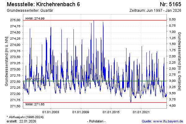
Groundwater level [m above sealevel]: 272.82
Distance to surface [m]: 2.71
Last value from 08.03.2026 09:30
Ground level [m above sealevel]: 275.53
| Date | Groundwater level [m above sealevel] |
|---|---|
| 08.03.2026 | 272.84 |
| 07.03.2026 | 272.87 |
| 06.03.2026 | 272.92 |
| 05.03.2026 | 272.99 |
| 04.03.2026 | 273.07 |
| 03.03.2026 | 273.15 |
| 02.03.2026 | 273.24 |
| 01.03.2026 | 273.34 |
© Bayerisches Landesamt für Umwelt 2026