
- Start >
- Groundwater >
- Waterlevel of upper layer >
- Bayern >
- Illerberg, Kässbohrer Ost (BGW 7) >
- Chart of total period

Chart of total period Illerberg, Kässbohrer Ost (BGW 7)
Groundwater levels of the total period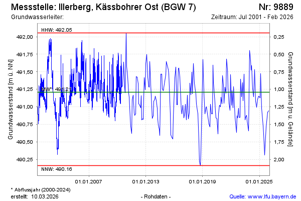
Groundwater level [m above sealevel]: 490.92
Distance to surface [m]: 1.33
Last value from 10.11.2025 08:40
Ground level [m above sealevel]: 492.25
| Date | Groundwater level [m above sealevel] |
|---|---|
| 23.09.2025 | 490.71 |
| 21.07.2025 | 490.31 |
| 10.06.2025 | 490.61 |
| 16.05.2025 | 490.73 |
| 20.03.2025 | 490.98 |
| 17.02.2025 | 491.48 |
| 23.01.2025 | 491.13 |
| 05.12.2024 | 491.15 |
© Bayerisches Landesamt für Umwelt 2025