
- Start >
- Groundwater >
- Waterlevel of upper layer >
- Bayern >
- GERSTH. OT.HIRBL. 652 >
- Chart of total period

Chart of total period GERSTH. OT.HIRBL. 652
Groundwater levels of the total period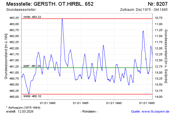
Groundwater level [m above sealevel]: 461.60
Distance to surface [m]: 12.40
Last value from 31.10.1995 23:59
Ground level [m above sealevel]: 474.00
| Date | Groundwater level [m above sealevel] |
|---|---|
| 29.10.1995 | 461.61 |
| 28.10.1995 | 461.63 |
| 25.10.1995 | 461.66 |
| 23.10.1995 | 461.68 |
| 17.10.1995 | 461.73 |
| 10.10.1995 | 461.77 |
| 09.10.1995 | 461.78 |
| 08.10.1995 | 461.79 |
© Bayerisches Landesamt für Umwelt 2026