
- Start >
- Groundwater >
- Waterlevel of upper layer >
- Bayern >
- FORSTH KIRCHSEEON 304A >
- Chart of total period

Chart of total period FORSTH KIRCHSEEON 304A
Groundwater levels of the total period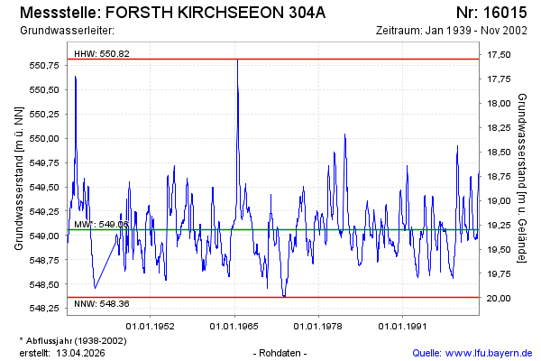
note
Die Messstelle wird nicht mehr beobachtet.
Groundwater level [m above sealevel]: 549.66
Distance to surface [m]: 18.70
Last value from 28.11.2002 10:00
Ground level [m above sealevel]: 568.36
| Date | Groundwater level [m above sealevel] |
|---|---|
| 21.11.2002 | 549.66 |
| 14.11.2002 | 549.66 |
| 07.11.2002 | 549.64 |
| 31.10.2002 | 549.63 |
| 24.10.2002 | 549.64 |
| 17.10.2002 | 549.64 |
| 10.10.2002 | 549.63 |
| 03.10.2002 | 549.62 |
© Bayerisches Landesamt für Umwelt 2026