
- Start >
- Groundwater >
- Waterlevel of upper layer >
- Bayern >
- Flussraummanagement Vils, MQS 04-L (ML04) >
- Current data

Current data Flussraummanagement Vils, MQS 04-L (ML04)
Groundwater levels of the last 12 months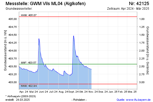
Groundwater level [m above sealevel]: 403.36
Distance to surface [m]: 2.64
Last value from 25.03.2026 10:35
Ground level [m above sealevel]: 406.00
| Date | Groundwater level [m above sealevel] |
|---|---|
| 25.03.2026 | 403.35 |
| 24.03.2026 | 403.34 |
| 23.03.2026 | 403.35 |
| 22.03.2026 | 403.36 |
| 21.03.2026 | 403.37 |
| 20.03.2026 | 403.38 |
| 19.03.2026 | 403.39 |
| 18.03.2026 | 403.39 |
© Bayerisches Landesamt für Umwelt 2026