
- Start >
- Groundwater >
- Waterlevel of upper layer >
- Bayern >
- DEGGENDORF-STADTP.675 >
- Chart of total period

Chart of total period DEGGENDORF-STADTP.675
Groundwater levels of the total period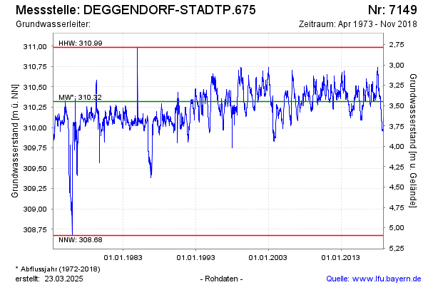
note
GW Messstelle im SN Bebauung DEG
Groundwater level [m above sealevel]: 309.91
Distance to surface [m]: 3.86
Last value from 21.11.2018 09:50
Ground level [m above sealevel]: 313.77
| Date | Groundwater level [m above sealevel] |
|---|---|
| 21.11.2018 | 310.06 |
| 20.11.2018 | 310.00 |
| 19.11.2018 | 310.03 |
| 18.11.2018 | 310.09 |
| 17.11.2018 | 310.13 |
| 16.11.2018 | 310.12 |
| 15.11.2018 | 310.08 |
| 14.11.2018 | 310.07 |
© Bayerisches Landesamt für Umwelt 2026