
- Start >
- Groundwater >
- Waterlevel of upper layer >
- Bayern >
- BISCHOF-BERNHARDTST.11 >
- Chart of total period

Chart of total period BISCHOF-BERNHARDTST.11
Groundwater levels of the total period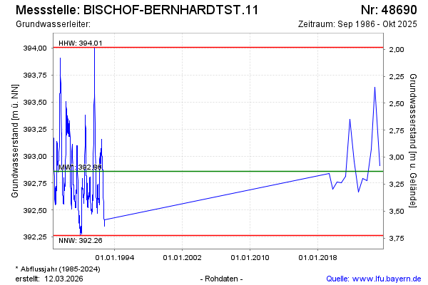
note
Die Messstelle wird nicht mehr beobachtet
Groundwater level [m above sealevel]: 392.61
Distance to surface [m]: 3.38
Last value from 15.10.2025 09:40
Ground level [m above sealevel]: 395.99
| Date | Groundwater level [m above sealevel] |
|---|---|
| 10.10.2024 | 393.64 |
| 16.04.2024 | 393.06 |
| 19.10.2023 | 392.77 |
| 19.04.2023 | 392.79 |
| 18.10.2022 | 392.67 |
| 13.04.2022 | 392.95 |
| 12.10.2021 | 393.34 |
| 14.04.2021 | 392.81 |
© Bayerisches Landesamt für Umwelt 2026