
- Start >
- Groundwater >
- Waterlevel of upper layer >
- Bayern >
- Altablagerung Sontheim GWM 1/09 >
- Chart of total period

Chart of total period Altablagerung Sontheim GWM 1/09
Groundwater levels of the total period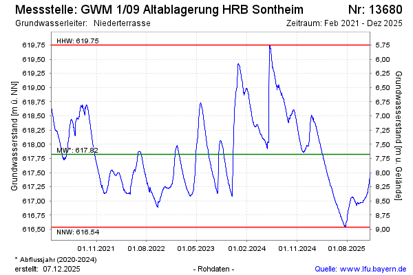
Groundwater level [m above sealevel]: 617.64
Distance to surface [m]: 7.86
Last value from 11.12.2025 10:00
Ground level [m above sealevel]: 625.50
| Date | Groundwater level [m above sealevel] |
|---|---|
| 11.12.2025 | 617.64 |
| 10.12.2025 | 617.62 |
| 09.12.2025 | 617.59 |
| 08.12.2025 | 617.56 |
| 07.12.2025 | 617.52 |
| 06.12.2025 | 617.49 |
| 05.12.2025 | 617.46 |
| 04.12.2025 | 617.43 |
© Bayerisches Landesamt für Umwelt 2025