
- Start >
- Groundwater >
- Waterlevel of deep layer >
- Regnitz >
- ROETTENBACH (K-1) >
- Chart of total period

Chart of total period ROETTENBACH (K-1)
Groundwater levels of the total period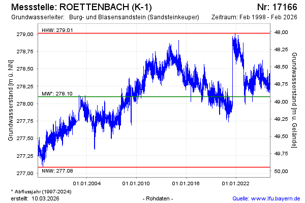
Groundwater level [m above sealevel]: 278.27
Distance to surface [m]: 48.76
Last value from 20.04.2026 09:33
Ground level [m above sealevel]: 327.03
| Date | Groundwater level [m above sealevel] |
|---|---|
| 20.04.2026 | 278.27 |
| 19.04.2026 | 278.28 |
| 18.04.2026 | 278.26 |
| 17.04.2026 | 278.24 |
| 16.04.2026 | 278.24 |
| 15.04.2026 | 278.24 |
| 14.04.2026 | 278.28 |
| 13.04.2026 | 278.33 |
© Bayerisches Landesamt für Umwelt 2026