
- Start >
- Groundwater >
- Waterlevel of deep layer >
- Regnitz >
- Ettenstadt-Reuth u. Neuhaus >
- Current data

Current data Ettenstadt-Reuth u. Neuhaus
Groundwater levels of the last 12 months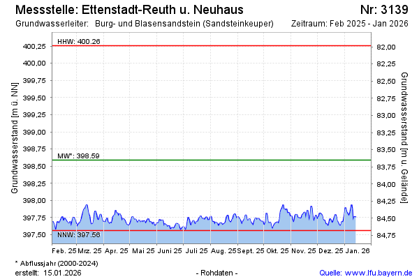
Groundwater level [m above sealevel]: 397.57
Distance to surface [m]: 84.67
Last value from 08.05.2026 13:00
Ground level [m above sealevel]: 482.24
| Date | Groundwater level [m above sealevel] |
|---|---|
| 08.05.2026 | 397.60 |
| 07.05.2026 | 397.63 |
| 06.05.2026 | 397.67 |
| 05.05.2026 | 397.65 |
| 04.05.2026 | 397.60 |
| 03.05.2026 | 397.59 |
| 02.05.2026 | 397.54 |
| 01.05.2026 | 397.50 |
© Bayerisches Landesamt für Umwelt 2026