
- Start >
- Groundwater >
- Waterlevel of deep layer >
- Obere Donau >
- OBERSTEINBACH (K-8) >
- Chart of total period

Chart of total period OBERSTEINBACH (K-8)
Groundwater levels of the total period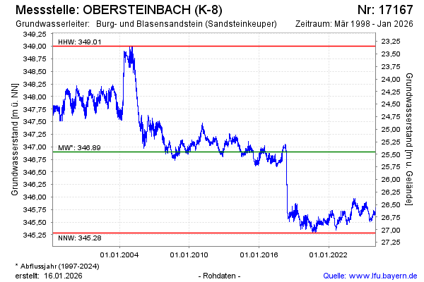
Groundwater level [m above sealevel]: 345.79
Distance to surface [m]: 26.56
Last value from 07.05.2026 10:49
Ground level [m above sealevel]: 372.35
| Date | Groundwater level [m above sealevel] |
|---|---|
| 07.05.2026 | 345.80 |
| 06.05.2026 | 345.80 |
| 05.05.2026 | 345.80 |
| 04.05.2026 | 345.78 |
| 03.05.2026 | 345.78 |
| 02.05.2026 | 345.76 |
| 01.05.2026 | 345.75 |
| 30.04.2026 | 345.75 |
© Bayerisches Landesamt für Umwelt 2026