
- Start >
- Groundwater >
- Waterlevel of deep layer >
- Inn >
- Hölsbrunn T2 >
- Chart of total period

Chart of total period Hölsbrunn T2
Groundwater levels of the total period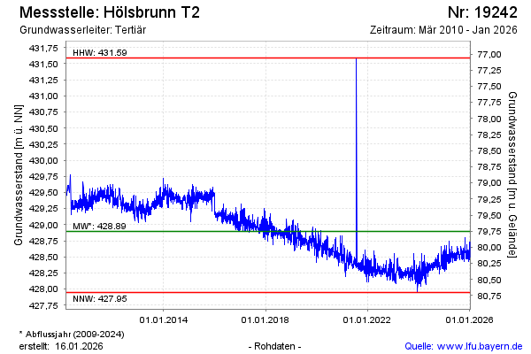
note
GW Messstelle im Grundnetz
Groundwater level [m above sealevel]: 428.32
Distance to surface [m]: 80.33
Last value from 22.05.2026 08:00
Ground level [m above sealevel]: 508.65
| Date | Groundwater level [m above sealevel] |
|---|---|
| 22.05.2026 | 428.33 |
| 21.05.2026 | 428.34 |
| 20.05.2026 | 428.39 |
| 19.05.2026 | 428.43 |
| 18.05.2026 | 428.48 |
| 17.05.2026 | 428.48 |
| 16.05.2026 | 428.56 |
| 15.05.2026 | 428.64 |
© Bayerisches Landesamt für Umwelt 2026