
- Start >
- Groundwater >
- Waterlevel of deep layer >
- Iller - Lech - Bodensee >
- Roggenburg T 13 >
- Current data

Current data Roggenburg T 13
Groundwater levels of the last 12 months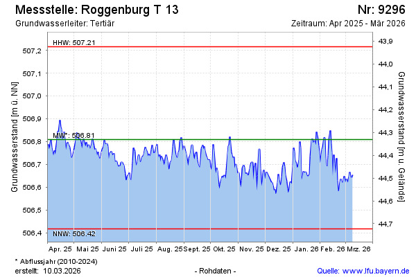
Groundwater level [m above sealevel]: 506.68
Distance to surface [m]: 44.46
Last value from 02.05.2026 11:00
Ground level [m above sealevel]: 551.14
| Date | Groundwater level [m above sealevel] |
|---|---|
| 02.05.2026 | 506.68 |
| 01.05.2026 | 506.66 |
| 30.04.2026 | 506.67 |
| 29.04.2026 | 506.70 |
| 28.04.2026 | 506.72 |
| 27.04.2026 | 506.69 |
| 26.04.2026 | 506.69 |
| 25.04.2026 | 506.71 |
© Bayerisches Landesamt für Umwelt 2026