
- Start >
- Groundwater >
- Waterlevel of deep layer >
- Iller - Lech - Bodensee >
- GERSTHOFEN TB NR. 9 >
- Current data

Current data GERSTHOFEN TB NR. 9
Groundwater levels of the last 12 months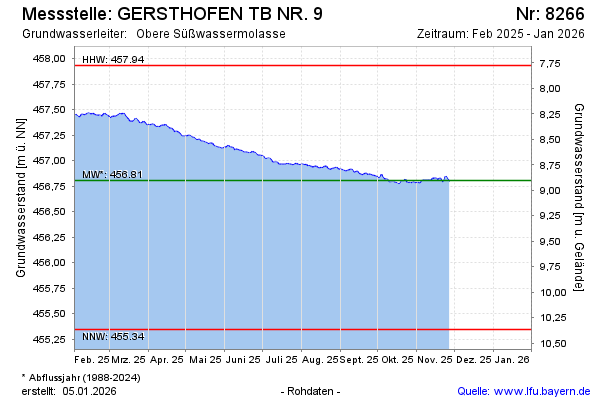
Groundwater level [m above sealevel]: 456.80
Distance to surface [m]: 8.91
Last value from 23.04.2026 10:55
Ground level [m above sealevel]: 465.71
| Date | Groundwater level [m above sealevel] |
|---|---|
| 23.04.2026 | 456.80 |
| 22.04.2026 | 456.81 |
| 21.04.2026 | 456.82 |
| 20.04.2026 | 456.82 |
| 19.04.2026 | 456.82 |
| 18.04.2026 | 456.82 |
| 17.04.2026 | 456.82 |
| 16.04.2026 | 456.81 |
© Bayerisches Landesamt für Umwelt 2026