
- Start >
- Groundwater >
- Waterlevel of deep layer >
- Bayern >
- TAUFKIRCHEN B. MUE. >
- Current data

Current data TAUFKIRCHEN B. MUE.
Groundwater levels of the last 12 months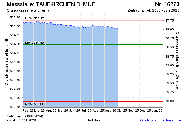
note
Datenaktualisierung erfolgt quartalsweise
Groundwater level [m above sealevel]: 534.89
Distance to surface [m]: 38.02
Last value from 21.01.2026 14:00
Ground level [m above sealevel]: 572.91
| Date | Groundwater level [m above sealevel] |
|---|---|
| 21.01.2026 | 534.87 |
| 20.01.2026 | 534.85 |
| 19.01.2026 | 534.85 |
| 18.01.2026 | 534.85 |
| 17.01.2026 | 534.85 |
| 16.01.2026 | 534.86 |
| 15.01.2026 | 534.87 |
| 14.01.2026 | 534.87 |
© Bayerisches Landesamt für Umwelt 2026