
- Start >
- Groundwater >
- Waterlevel of deep layer >
- Bayern >
- NOPPLINGER FELD TB846 >
- Chart of total period

Chart of total period NOPPLINGER FELD TB846
Groundwater levels of the total period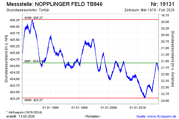
note
GW Messstelle im Grundnetz
Groundwater level [m above sealevel]: 423.37
Distance to surface [m]: 22.81
Last value from 31.03.2026 00:00
Ground level [m above sealevel]: 446.18
| Date | Groundwater level [m above sealevel] |
|---|---|
| 30.03.2026 | 424.27 |
| 29.03.2026 | 424.23 |
| 28.03.2026 | 424.25 |
| 27.03.2026 | 424.23 |
| 26.03.2026 | 424.27 |
| 25.03.2026 | 424.32 |
| 24.03.2026 | 424.25 |
| 23.03.2026 | 424.26 |
© Bayerisches Landesamt für Umwelt 2026