
- Start >
- Groundwater >
- Waterlevel of deep layer >
- Bayern >
- Hergolshausen MU1 >
- Chart of total period

Chart of total period Hergolshausen MU1
Groundwater levels of the total period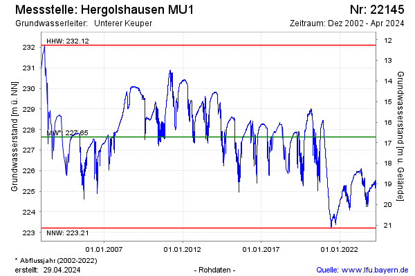
note
Grundwasserstand durch Entnahme beeinflusst
Groundwater level [m above sealevel]: 225.78
Distance to surface [m]: 18.58
Last value from 09.12.2025 10:00
Ground level [m above sealevel]: 244.36
| Date | Groundwater level [m above sealevel] |
|---|---|
| 09.12.2025 | 225.80 |
| 08.12.2025 | 225.80 |
| 07.12.2025 | 225.82 |
| 06.12.2025 | 225.83 |
| 05.12.2025 | 225.84 |
| 04.12.2025 | 225.85 |
| 03.12.2025 | 225.84 |
| 02.12.2025 | 225.83 |
© Bayerisches Landesamt für Umwelt 2025