
- Start >
- Groundwater >
- Waterlevel of deep layer >
- Bayern >
- HENGERSBERG BR I >
- Current data

Current data HENGERSBERG BR I
Groundwater levels of the last 12 months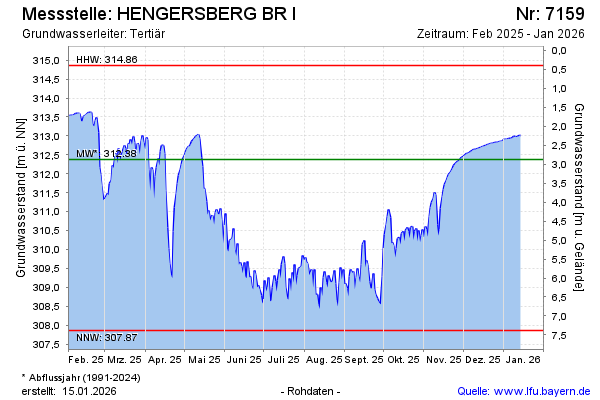
note
GW Messstelle im Verdichtungsnetz
Groundwater level [m above sealevel]: 313.56
Distance to surface [m]: 1.69
Last value from 02.05.2026 21:00
Ground level [m above sealevel]: 315.25
| Date | Groundwater level [m above sealevel] |
|---|---|
| 02.05.2026 | 313.55 |
| 01.05.2026 | 313.54 |
| 30.04.2026 | 313.54 |
| 29.04.2026 | 313.54 |
| 28.04.2026 | 313.54 |
| 27.04.2026 | 313.53 |
| 26.04.2026 | 313.52 |
| 25.04.2026 | 313.51 |
© Bayerisches Landesamt für Umwelt 2026