
- Start >
- Groundwater >
- Waterlevel of deep layer >
- Bayern >
- GROSSKOELLNBACH T8 >
- Chart of total period

Chart of total period GROSSKOELLNBACH T8
Groundwater levels of the total period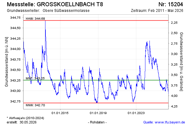
note
Werte ab 22.10.2025 falsch! Kein neuer Niedrigstwert!
Groundwater level [m above sealevel]: 343.14
Distance to surface [m]: 3.74
Last value from 13.04.2026 10:00
Ground level [m above sealevel]: 346.88
| Date | Groundwater level [m above sealevel] |
|---|---|
| 13.04.2026 | 343.15 |
| 12.04.2026 | 343.14 |
| 11.04.2026 | 343.14 |
| 10.04.2026 | 343.14 |
| 09.04.2026 | 343.14 |
| 08.04.2026 | 343.14 |
| 07.04.2026 | 343.15 |
| 06.04.2026 | 343.15 |
© Bayerisches Landesamt für Umwelt 2026