
- Start >
- Groundwater >
- Waterlevel of deep layer >
- Bayern >
- GEISELHARTING A F 856 >
- Chart of total period

Chart of total period GEISELHARTING A F 856
Groundwater levels of the total period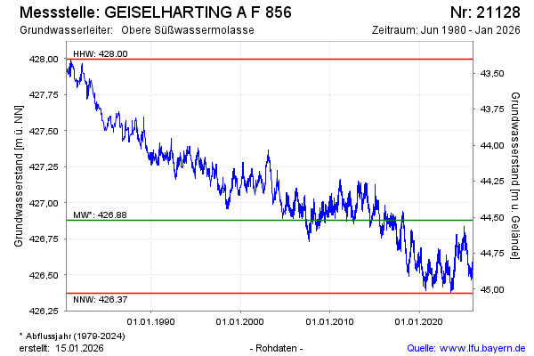
Groundwater level [m above sealevel]: 426.65
Distance to surface [m]: 44.75
Last value from 03.05.2024 10:00
Ground level [m above sealevel]: 471.40
| Date | Groundwater level [m above sealevel] |
|---|---|
| 03.05.2024 | 426.66 |
| 02.05.2024 | 426.69 |
| 01.05.2024 | 426.67 |
| 30.04.2024 | 426.66 |
| 29.04.2024 | 426.65 |
| 28.04.2024 | 426.67 |
| 27.04.2024 | 426.68 |
| 26.04.2024 | 426.69 |
© Bayerisches Landesamt für Umwelt 2024