
- Startseite >
- Flüsse >
- Wasserstand >
- Obere Donau >
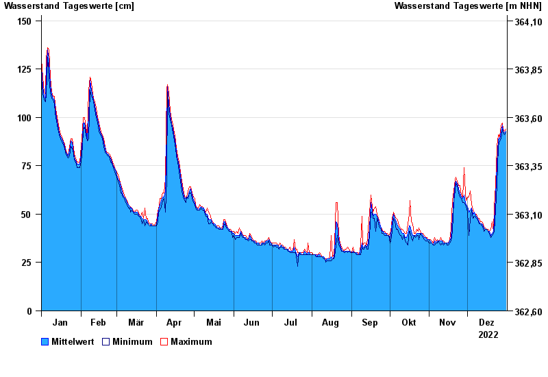
- Beilngries oberh. der Sulz >
- Jahresgrafik

Jahresgrafik Beilngries oberh. der Sulz / Altmühl
Wasserstand vom 01.01.2022 bis zum 31.12.2022
- 18.03.1988 Wasserstand: 299 cm
- 03.03.1987 Wasserstand: 288 cm
- 29.03.1988 Wasserstand: 275 cm
- 24.12.1993 Wasserstand: 274 cm
- 15.01.2011 Wasserstand: 270 cm
| Datum | Mittelwert [cm] | Maximum [cm] | Minimum [cm] |
|---|---|---|---|
| 31.12.2022 | 93 | 94 | 92 |
| 30.12.2022 | 92 | 93 | 91 |
| 29.12.2022 | 93 | 94 | 92 |
| 28.12.2022 | 96 | 97 | 94 |
| 27.12.2022 | 93 | 96 | 89 |
| 26.12.2022 | 89 | 90 | 88 |
| 25.12.2022 | 89 | 91 | 85 |
© Bayerisches Landesamt für Umwelt 2024