
- Startseite >
- Flüsse >
- Wasserstand >
- Obere Donau >
- Aeschach >
- Jahresgrafik

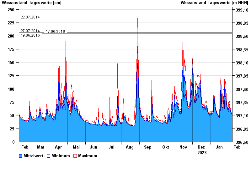
Jahresgrafik Aeschach / Oberreitnauer Ach
Wasserstand vom 07.02.2023 bis zum 06.02.2024
- 02.06.2013 Wasserstand: 285 cm
- 22.07.2014 Wasserstand: 232 cm
- 27.07.2014 Wasserstand: 206 cm
- 17.06.2016 Wasserstand: 205 cm
- 19.06.2016 Wasserstand: 198 cm
| Datum | Mittelwert [cm] | Maximum [cm] | Minimum [cm] |
|---|---|---|---|
| 06.02.2024 | 53 | 54 | 52 |
| 05.02.2024 | 55 | 56 | 54 |
| 04.02.2024 | 58 | 60 | 56 |
| 03.02.2024 | 63 | 66 | 60 |
| 02.02.2024 | 71 | 77 | 66 |
| 01.02.2024 | 65 | 79 | 56 |
| 31.01.2024 | 59 | 61 | 58 |
© Bayerisches Landesamt für Umwelt 2024