
- Startseite >
- Flüsse >
- Wasserstand >
- Oberer Main - Elbe >
- Laufermühle >
- Jahresgrafik

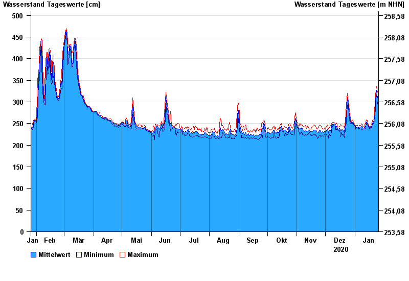
Jahresgrafik Laufermühle / Aisch
Wasserstand vom 26.01.2020 bis zum 25.01.2021
- 10.07.2021 Wasserstand: 609 cm
- 01.06.2013 Wasserstand: 584 cm
- 26.01.1995 Wasserstand: 563 cm
- 09.01.2011 Wasserstand: 553 cm
- 30.10.1998 Wasserstand: 548 cm
| Datum | Mittelwert [cm] | Maximum [cm] | Minimum [cm] |
|---|---|---|---|
| 25.01.2021 | 309 | 323 | 295 |
| 24.01.2021 | 327 | 335 | 316 |
| 23.01.2021 | 304 | 316 | 298 |
| 22.01.2021 | 273 | 299 | 255 |
| 21.01.2021 | 255 | 258 | 253 |
| 20.01.2021 | 254 | 260 | 249 |
| 19.01.2021 | 246 | 250 | 244 |
© Bayerisches Landesamt für Umwelt 2024