
- Startseite >
- Flüsse >
- Wasserstand >
- Oberer Main - Elbe >
- Laufermühle >
- Jahresgrafik

Jahresgrafik Laufermühle / Aisch
Wasserstand vom 26.01.2021 bis zum 25.01.2022
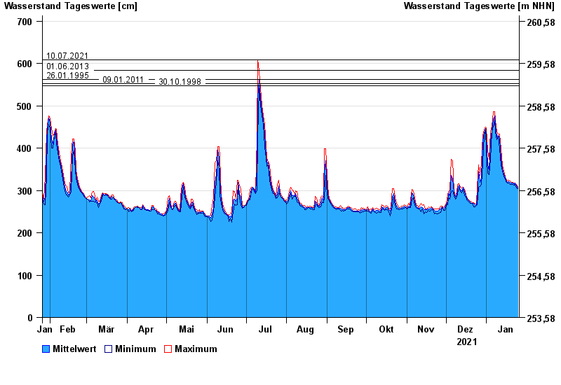
- 10.07.2021 Wasserstand: 609 cm
- 01.06.2013 Wasserstand: 584 cm
- 26.01.1995 Wasserstand: 563 cm
- 09.01.2011 Wasserstand: 553 cm
- 30.10.1998 Wasserstand: 548 cm
| Datum | Mittelwert [cm] | Maximum [cm] | Minimum [cm] |
|---|---|---|---|
| 25.01.2022 | 305 | 307 | 304 |
| 24.01.2022 | 312 | 315 | 306 |
| 23.01.2022 | 317 | 318 | 314 |
| 22.01.2022 | 315 | 318 | 313 |
| 21.01.2022 | 318 | 319 | 314 |
| 20.01.2022 | 317 | 319 | 315 |
| 19.01.2022 | 319 | 323 | 315 |
© Bayerisches Landesamt für Umwelt 2024