
- Startseite >
- Flüsse >
- Wasserstand >
- Bayern >
- Untersteinach >
- Jahresgrafik

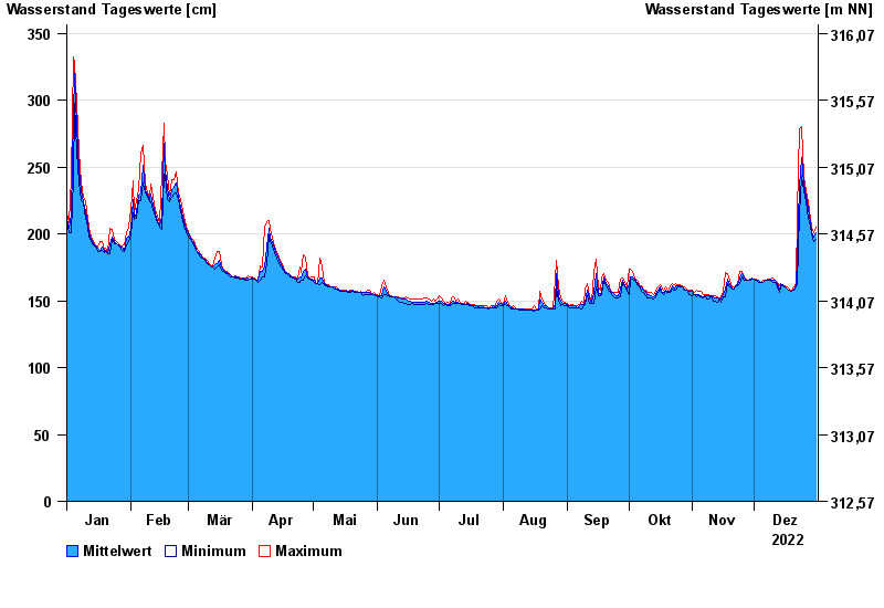
Jahresgrafik Untersteinach / Schorgast
Wasserstand vom 01.01.2022 bis zum 31.12.2022
Hinweis
Schlechte Netzanbindung
- 28.05.2006 Wasserstand: 379 cm
- 03.01.2003 Wasserstand: 373 cm
- 01.11.1998 Wasserstand: 367 cm
- 13.02.2005 Wasserstand: 357 cm
- 16.09.1998 Wasserstand: 357 cm
| Datum | Mittelwert [cm] | Maximum [cm] | Minimum [cm] |
|---|---|---|---|
| 31.12.2022 | 201 | 205 | 196 |
| 30.12.2022 | 198 | 201 | 194 |
| 29.12.2022 | 202 | 205 | 200 |
| 28.12.2022 | 209 | 212 | 205 |
| 27.12.2022 | 218 | 224 | 212 |
| 26.12.2022 | 228 | 232 | 224 |
| 25.12.2022 | 237 | 243 | 232 |
© Bayerisches Landesamt für Umwelt 2024