
- Start >
- Groundwater >
- Waterlevel of upper layer >
- Bayern >
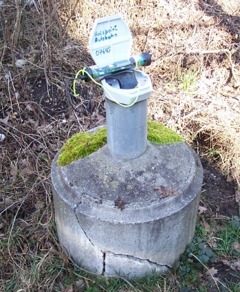
- HOLZPAINT (AUTOBAHN) >
- Master data

Master data HOLZPAINT (AUTOBAHN)
Site number: 7645
Measuring point system: Staatliches Sondernetz
Community: Plattling
District: Deggendorf
Operator:  Wasserwirtschaftsamt Deggendorf
Aquifer:
Measurement site depth under ground: 8.20 m
Ground level: 314.63 m above sealevel
Easting: 787591 (ETRS89 / UTM Zone 32N)
Northing: 5412679
Observation period: 01.08.1996 to 31.01.2024
Maximum waterlevel (HHW): 315.83 m above sealevel
Mean waterlevel (MW): 313.80 m above sealevel
Minimum waterlevel (NNW): 313.01 m above sealevel
Mean Highest Groundwater Level (MHGW): 314.37 m above sealevel (Period: 01.11.1995 - 01.11.2024)
Picture of the measurement site
Location of the station HOLZPAINT (AUTOBAHN)
| Measurement site | Category |
|---|---|
 Pfelling Pfelling | Rivers: Runoff, Waterlevel |
| Hofkirchen | Rivers: Runoff, Waterlevel |
| Haberkofen | Rivers: Runoff, Waterlevel |
| Deggendorf | Rivers: Runoff, Waterlevel |