
- Start >
- Groundwater >
- Waterlevel of upper layer >
- Bayern >
- Treuchtlingen-Graben (13/85) >
- Chart of total period

Chart of total period Treuchtlingen-Graben (13/85)
Groundwater levels of the total period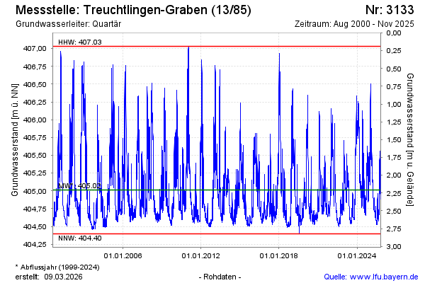
Groundwater level [m above sealevel]: 405.38
Distance to surface [m]: 1.84
Last value from 03.11.2025 13:47
Ground level [m above sealevel]: 407.22
| Date | Groundwater level [m above sealevel] |
|---|---|
| 03.11.2025 | 405.40 |
| 02.11.2025 | 405.36 |
| 01.11.2025 | 405.39 |
| 31.10.2025 | 405.42 |
| 30.10.2025 | 405.43 |
| 29.10.2025 | 405.45 |
| 28.10.2025 | 405.45 |
| 27.10.2025 | 405.32 |
© Bayerisches Landesamt für Umwelt 2026