
- Startseite >
- Seen >
- Wasserstand >
- Regnitz >
- Rothsee Hauptsperre >
- Aktuelle Messwerte

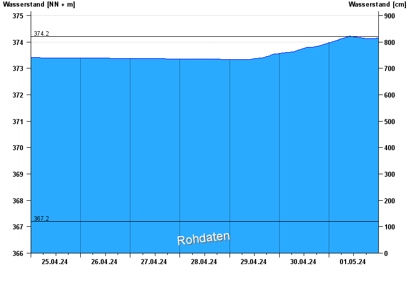
Aktuelle Messwerte Rothsee Hauptsperre / Rothsee
Wasserstand vom 25.04.2024 bis zum 01.05.2024
- 362,30 m ü. NN : Rothsee: Tiefstes Absenkziel
- 367,20 m ü. NN : Rothsee: Absenkziel
- 374,20 m ü. NN : Rothsee: Stauziel
- 375,26 m ü. NN : Rothsee: Hochwasserstauziel
- 377,20 m ü. NN : Rothsee: Dammkrone
Linien: keine | Hauptwerte | Meldestufen | mittlerer Seespiegel | Hochwassermarken | historische Ereignisse
| Datum | Wasserstand [m ü. NN] |
|---|---|
| 02.05.2024 00:45 | 374,15 |
| 02.05.2024 00:30 | 374,14 |
| 02.05.2024 00:15 | 374,14 |
| 02.05.2024 00:00 | 374,14 |
| 01.05.2024 23:45 | 374,14 |
| 01.05.2024 23:30 | 374,14 |
| 01.05.2024 23:15 | 374,14 |
© Bayerisches Landesamt für Umwelt 2024