
- Startseite >
- Seen >
- Wasserstand >
- Obere Donau >
- Rothsee Hauptsperre >
- Gesamtzeitraum

Gesamtzeitraum Rothsee Hauptsperre / Rothsee
Wasserstand vom 02.02.2006 bis zum 28.04.2024
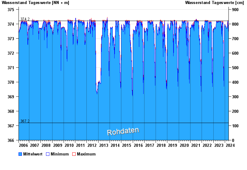
- 362,30 m ü. NN : Rothsee: Tiefstes Absenkziel
- 367,20 m ü. NN : Rothsee: Absenkziel
- 374,20 m ü. NN : Rothsee: Stauziel
- 375,26 m ü. NN : Rothsee: Hochwasserstauziel
- 377,20 m ü. NN : Rothsee: Dammkrone
Linien: keine | Hauptwerte | Meldestufen | mittlerer Seespiegel | Hochwassermarken | historische Ereignisse
| Datum | Mittelwert [m ü. NN] | Maximum [m ü. NN] | Minimum [m ü. NN] |
|---|---|---|---|
| 28.04.2024 | 373,35 | 373,36 | 373,35 |
| 27.04.2024 | 373,37 | 373,38 | 373,35 |
| 26.04.2024 | 373,39 | 373,39 | 373,38 |
| 25.04.2024 | 373,40 | 373,41 | 373,39 |
| 24.04.2024 | 373,41 | 373,41 | 373,40 |
| 23.04.2024 | 373,42 | 373,43 | 373,41 |
| 22.04.2024 | 373,43 | 373,43 | 373,42 |
© Bayerisches Landesamt für Umwelt 2024