
- Startseite >
- Seen >
- Wasserstand >
- Iller - Lech - Bodensee >
- Rottachsee >
- Aktuelle Messwerte

Aktuelle Messwerte Rottachsee / Rottachsee
Wasserstand vom 27.05.2023 bis zum 02.06.2023
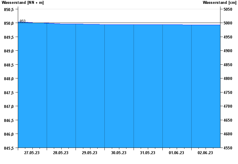
- 850,00 m ü. NN : Rottachspeicher: Stauziel
- 851,00 m ü. NN : Rottachspeicher: Hochwasserstauziel
- 853,50 m ü. NN : Rottachspeicher: Dammkrone
- 840,00 m ü. NN : Rottachspeicher: Absenkziel
- 818,00 m ü. NN : Rottachspeicher: Tiefstes Absenkziel
Linien: keine | Hauptwerte | Meldestufen | mittlerer Seespiegel | Hochwassermarken | historische Ereignisse
| Datum | Wasserstand [m ü. NN] |
|---|---|
| 03.06.2023 00:45 | 849,93 |
| 03.06.2023 00:30 | 849,93 |
| 03.06.2023 00:15 | 849,93 |
| 03.06.2023 00:00 | 849,93 |
| 02.06.2023 23:45 | 849,93 |
| 02.06.2023 23:30 | 849,93 |
| 02.06.2023 23:15 | 849,93 |
© Bayerisches Landesamt für Umwelt 2024