
- Startseite >
- Grundwasser >
- Wasserstand tiefere Stockwerke >
- Obere Donau >
- Kellmünz T 19 >
- Gesamtzeitraum

Gesamtzeitraum Kellmünz T 19
Grundwasserstände im Gesamtzeitraum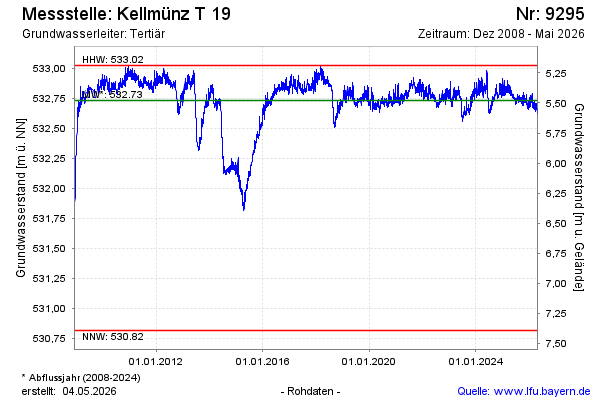
Grundwasserstand [m ü. NN]: 532,76
Flurabstand [m u. Gelände]: 5,45
Letzter Messwert vom 09.01.2026 08:00
Geländehöhe [m ü. NN]: 538,21
| Datum | Grundwasserstand [m ü. NN] |
|---|---|
| 09.01.2026 | 532,75 |
| 08.01.2026 | 532,72 |
| 07.01.2026 | 532,70 |
| 06.01.2026 | 532,70 |
| 05.01.2026 | 532,71 |
| 04.01.2026 | 532,71 |
| 03.01.2026 | 532,73 |
| 02.01.2026 | 532,74 |
© Bayerisches Landesamt für Umwelt 2026