
- Startseite >
- Grundwasser >
- Wasserstand tiefere Stockwerke >
- Bayern >
- THANNHAUSEN B,FB 890 >
- Gesamtzeitraum

Gesamtzeitraum THANNHAUSEN B,FB 890
Grundwasserstände im Gesamtzeitraum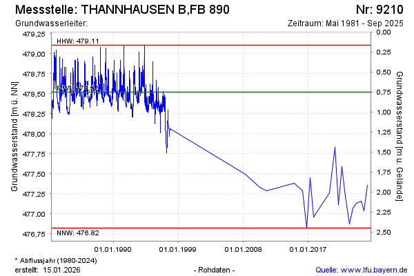
Grundwasserstand [m ü. NN]: 477,16
Flurabstand [m u. Gelände]: 2,11
Letzter Messwert vom 11.04.2024 10:00
Geländehöhe [m ü. NN]: 479,27
| Datum | Grundwasserstand [m ü. NN] |
|---|---|
| 05.09.2023 | 477,13 |
| 23.02.2023 | 477,07 |
| 02.09.2022 | 476,87 |
| 17.02.2022 | 477,22 |
| 07.09.2021 | 477,59 |
| 02.03.2021 | 477,11 |
| 02.09.2020 | 477,83 |
| 12.03.2020 | 477,48 |
© Bayerisches Landesamt für Umwelt 2024