
- Startseite >
- Grundwasser >
- Wasserstand tiefere Stockwerke >
- Bayern >
- Eschenried T 17f >
- Gesamtzeitraum

Gesamtzeitraum Eschenried T 17f
Grundwasserstände im Gesamtzeitraum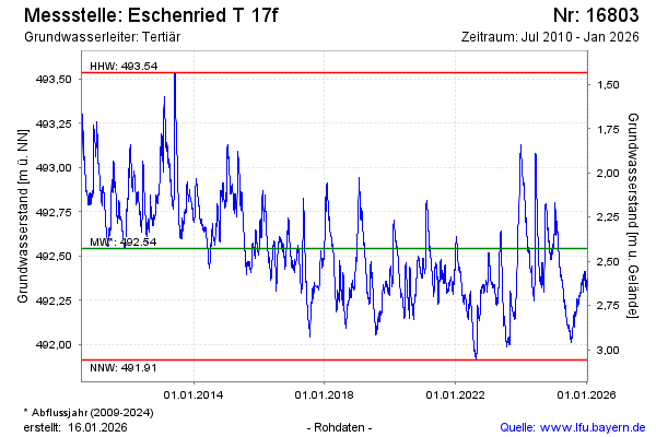
Grundwasserstand [m ü. NN]: 492,38
Flurabstand [m u. Gelände]: 2,55
Letzter Messwert vom 26.07.2024 10:00
Geländehöhe [m ü. NN]: 494,93
| Datum | Grundwasserstand [m ü. NN] |
|---|---|
| 25.07.2024 | 492,39 |
| 24.07.2024 | 492,38 |
| 23.07.2024 | 492,38 |
| 22.07.2024 | 492,38 |
| 21.07.2024 | 492,39 |
| 20.07.2024 | 492,41 |
| 19.07.2024 | 492,42 |
| 18.07.2024 | 492,43 |
© Bayerisches Landesamt für Umwelt 2024