
- Startseite >
- Grundwasser >
- Wasserstand oberes Stockwerk >
- Bayern >
- B02-Wassermauth >
- Aktuelle Daten

Aktuelle Daten B02-Wassermauth
Grundwasserstände der letzten 12 Monate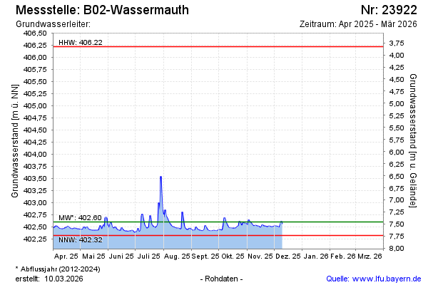
Grundwasserstand [m ü. NN]: 402,45
Flurabstand [m u. Gelände]: 7,60
Letzter Messwert vom 13.01.2026 17:00
Geländehöhe [m ü. NN]: 410,05
| Datum | Grundwasserstand [m ü. NN] |
|---|---|
| 13.01.2026 | 402,43 |
| 12.01.2026 | 402,41 |
| 11.01.2026 | 402,41 |
| 10.01.2026 | 402,42 |
| 09.01.2026 | 402,42 |
| 08.01.2026 | 402,42 |
| 07.01.2026 | 402,42 |
| 06.01.2026 | 402,43 |
 weitere Messwerte weitere Messwerte | |

© Bayerisches Landesamt für Umwelt 2026