
- Startseite >
- Flüsse >
- Wasserstand >
- Regnitz >
- Ansbach >
- Jahresgrafik

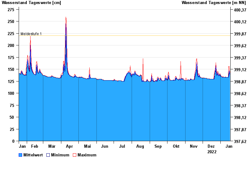
Jahresgrafik Ansbach / Fränkische Rezat
Wasserstand vom 18.01.2022 bis zum 17.01.2023
Hinweis
Wasserstand und Abfluss wird zeitweise durch Biberdamm beeinflusst.
- Meldestufe 1 220 cm
- Meldestufe 2 280 cm
- Meldestufe 3 340 cm
- Meldestufe 4 400 cm
- Hochwassergefahrenfläche HQ100 470 cm
| Datum | Mittelwert [cm] | Maximum [cm] | Minimum [cm] |
|---|---|---|---|
| 17.01.2023 | 141 | 142 | 139 |
| 16.01.2023 | 147 | 156 | 142 |
| 15.01.2023 | 139 | 156 | 133 |
| 14.01.2023 | 133 | 133 | 133 |
| 13.01.2023 | 133 | 133 | 133 |
| 12.01.2023 | 133 | 133 | 133 |
| 11.01.2023 | 133 | 133 | 133 |
© Bayerisches Landesamt für Umwelt 2024