
- Startseite >
- Flüsse >
- Wasserstand >
- Untere Donau >
- Auerbach >
- Jahresgrafik

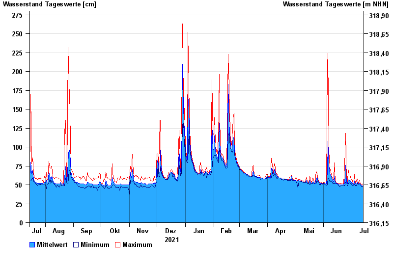
Jahresgrafik Auerbach / Hengersberger Ohe
Wasserstand vom 15.07.2021 bis zum 14.07.2022
- 13.08.2002 Wasserstand: 298 cm
- 26.03.2006 Wasserstand: 294 cm
- 28.01.2002 Wasserstand: 287 cm
- 20.03.2002 Wasserstand: 286 cm
- 29.10.1998 Wasserstand: 285 cm
| Datum | Mittelwert [cm] | Maximum [cm] | Minimum [cm] |
|---|---|---|---|
| 14.07.2022 | 49 | 51 | 48 |
| 13.07.2022 | 49 | 50 | 48 |
| 12.07.2022 | 50 | 51 | 49 |
| 11.07.2022 | 51 | 52 | 50 |
| 10.07.2022 | 52 | 56 | 51 |
| 09.07.2022 | 51 | 52 | 50 |
| 08.07.2022 | 53 | 58 | 52 |
© Bayerisches Landesamt für Umwelt 2024