
- Startseite >
- Flüsse >
- Wasserstand >
- Unterer Main >
- Schlimpfhof >
- Jahresgrafik

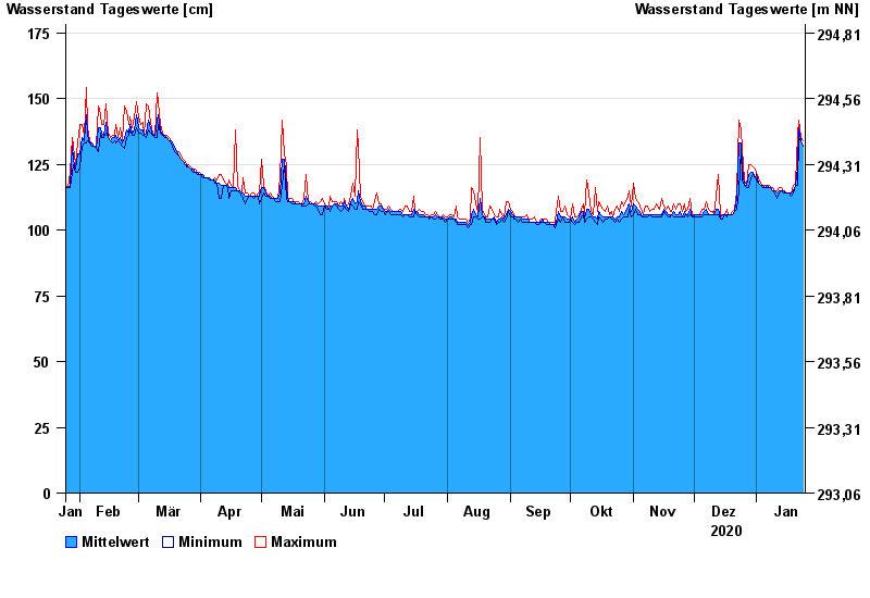
Jahresgrafik Schlimpfhof / Lauter
Wasserstand vom 25.01.2020 bis zum 24.01.2021
Hinweis
Pegel wird wegen Straßenbauarbeiten versetzt. Dauer der Maßnahme bis Ende 2023.
- 07.02.1984 Wasserstand: 232 cm
- 23.01.1995 Wasserstand: 209 cm
- 17.12.1974 Wasserstand: 209 cm
- 02.01.2003 Wasserstand: 201 cm
- 26.01.1995 Wasserstand: 199 cm
| Datum | Mittelwert [cm] | Maximum [cm] | Minimum [cm] |
|---|---|---|---|
| 24.01.2021 | 132 | 134 | 132 |
| 23.01.2021 | 134 | 135 | 134 |
| 22.01.2021 | 139 | 142 | 135 |
| 21.01.2021 | 124 | 136 | 117 |
| 20.01.2021 | 117 | 118 | 117 |
| 19.01.2021 | 115 | 117 | 114 |
| 18.01.2021 | 114 | 114 | 113 |
© Bayerisches Landesamt für Umwelt 2024