
- Startseite >
- Flüsse >
- Wasserstand >
- Iller - Lech - Bodensee >
- Türkheim >
- Jahresgrafik

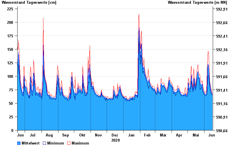
Jahresgrafik Türkheim / Wertach
Wasserstand vom 17.06.2020 bis zum 16.06.2021
Hinweis
Beeinflussung durch Kraftwerksbetrieb
- 23.08.2005 Wasserstand: 309 cm
- 12.08.2002 Wasserstand: 291 cm
- 02.06.2013 Wasserstand: 277 cm
- 06.08.2010 Wasserstand: 252 cm
- 03.06.2010 Wasserstand: 243 cm
| Datum | Mittelwert [cm] | Maximum [cm] | Minimum [cm] |
|---|---|---|---|
| 16.06.2021 | 66 | 68 | 65 |
| 15.06.2021 | 68 | 71 | 66 |
| 14.06.2021 | 72 | 76 | 69 |
| 13.06.2021 | 75 | 79 | 69 |
| 12.06.2021 | 80 | 84 | 74 |
| 11.06.2021 | 87 | 91 | 81 |
| 10.06.2021 | 102 | 121 | 91 |
© Bayerisches Landesamt für Umwelt 2024