
- Startseite >
- Flüsse >
- Wasserstand >
- Iller - Lech - Bodensee >
- Oberaudorf >
- Jahresgrafik

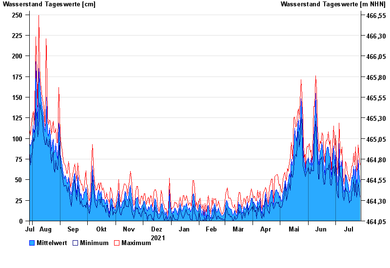
Jahresgrafik Oberaudorf / Inn
Wasserstand vom 29.07.2021 bis zum 28.07.2022
- 06.08.1985 Wasserstand: 617 cm
- 23.08.2005 Wasserstand: 537 cm
- 25.08.1987 Wasserstand: 510 cm
- 20.07.1987 Wasserstand: 507 cm
- 16.06.1987 Wasserstand: 410 cm
| Datum | Mittelwert [cm] | Maximum [cm] | Minimum [cm] |
|---|---|---|---|
| 28.07.2022 | 47 | 68 | 29 |
| 27.07.2022 | 58 | 79 | 38 |
| 26.07.2022 | 74 | 92 | 46 |
| 25.07.2022 | 53 | 67 | 37 |
| 24.07.2022 | 44 | 60 | 29 |
| 23.07.2022 | 67 | 90 | 49 |
| 22.07.2022 | 51 | 68 | 31 |
© Bayerisches Landesamt für Umwelt 2024