
- Startseite >
- Flüsse >
- Wasserstand >
- Iller - Lech - Bodensee >
- Gunzesried >
- Jahresgrafik

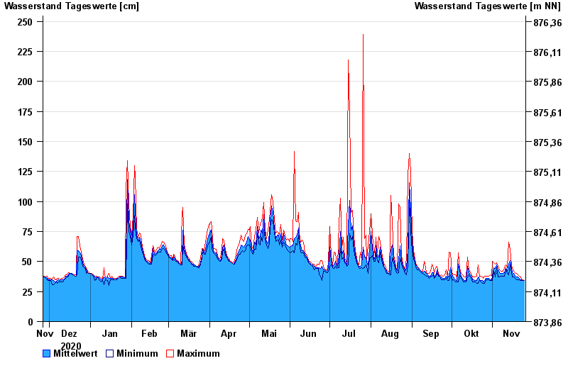
Jahresgrafik Gunzesried / Gunzesrieder Ach
Wasserstand vom 26.11.2020 bis zum 25.11.2021
- 22.08.2005 Wasserstand: 278 cm
- 22.05.1999 Wasserstand: 260 cm
- 12.06.2000 Wasserstand: 255 cm
- 15.02.1990 Wasserstand: 255 cm
- 25.08.2002 Wasserstand: 253 cm
| Datum | Mittelwert [cm] | Maximum [cm] | Minimum [cm] |
|---|---|---|---|
| 25.11.2021 | 34 | 34 | 34 |
| 24.11.2021 | 34 | 35 | 34 |
| 23.11.2021 | 35 | 35 | 34 |
| 22.11.2021 | 35 | 37 | 34 |
| 21.11.2021 | 36 | 38 | 35 |
| 20.11.2021 | 37 | 39 | 35 |
| 19.11.2021 | 37 | 40 | 35 |
© Bayerisches Landesamt für Umwelt 2024