
- Startseite >
- Flüsse >
- Wasserstand >
- Iller - Lech - Bodensee >
- Aeschach >
- Jahresgrafik

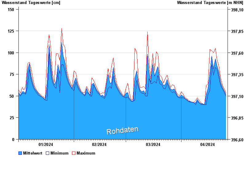
Jahresgrafik Aeschach / Oberreitnauer Ach
Wasserstand vom 01.01.2024 bis zum 26.04.2024
- 02.06.2013 Wasserstand: 285 cm
- 22.07.2014 Wasserstand: 232 cm
- 27.07.2014 Wasserstand: 206 cm
- 17.06.2016 Wasserstand: 205 cm
- 19.06.2016 Wasserstand: 198 cm
| Datum | Mittelwert [cm] | Maximum [cm] | Minimum [cm] |
|---|---|---|---|
| 26.04.2024 | 53 | 54 | 53 |
| 25.04.2024 | 56 | 58 | 54 |
| 24.04.2024 | 60 | 62 | 58 |
| 23.04.2024 | 66 | 71 | 62 |
| 22.04.2024 | 78 | 85 | 72 |
| 21.04.2024 | 85 | 92 | 81 |
| 20.04.2024 | 93 | 105 | 83 |
© Bayerisches Landesamt für Umwelt 2024