
- Startseite >
- Flüsse >
- Wasserstand >
- Oberer Main - Elbe >
- Unterzettlitz >
- Jahresgrafik

Jahresgrafik Unterzettlitz / Roter Main
Wasserstand vom 27.01.2020 bis zum 26.01.2021
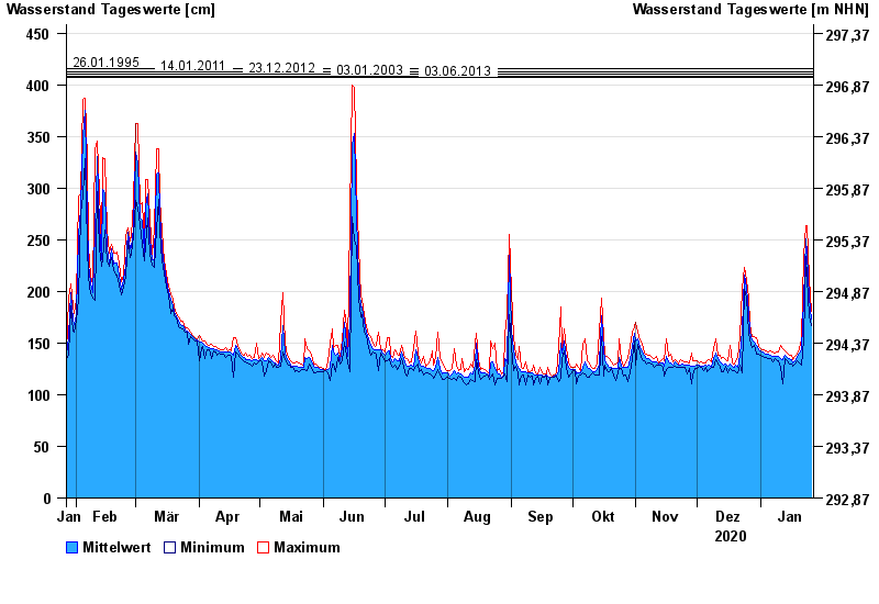
- 26.01.1995 Wasserstand: 416 cm
- 14.01.2011 Wasserstand: 413 cm
- 23.12.2012 Wasserstand: 410 cm
- 03.01.2003 Wasserstand: 408 cm
- 03.06.2013 Wasserstand: 407 cm
| Datum | Mittelwert [cm] | Maximum [cm] | Minimum [cm] |
|---|---|---|---|
| 26.01.2021 | 173 | 181 | 167 |
| 25.01.2021 | 193 | 213 | 177 |
| 24.01.2021 | 236 | 264 | 213 |
| 23.01.2021 | 251 | 264 | 234 |
| 22.01.2021 | 192 | 234 | 153 |
| 21.01.2021 | 144 | 154 | 129 |
| 20.01.2021 | 140 | 145 | 131 |
© Bayerisches Landesamt für Umwelt 2024