
- Startseite >
- Flüsse >
- Wasserstand >
- Oberer Main - Elbe >
- Schlehenmühle >
- Jahresgrafik

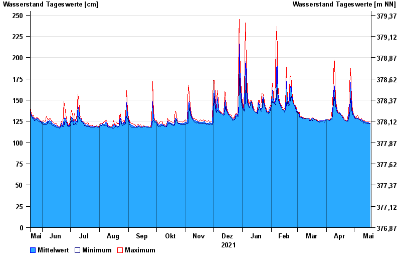
Jahresgrafik Schlehenmühle / Roter Main
Wasserstand vom 19.05.2021 bis zum 18.05.2022
- 26.01.1995 Wasserstand: 399 cm
- 06.06.1984 Wasserstand: 363 cm
- 13.01.2011 Wasserstand: 337 cm
- 07.02.1984 Wasserstand: 324 cm
- 21.03.2002 Wasserstand: 323 cm
| Datum | Mittelwert [cm] | Maximum [cm] | Minimum [cm] |
|---|---|---|---|
| 18.05.2022 | 123 | 125 | 122 |
| 17.05.2022 | 123 | 125 | 122 |
| 16.05.2022 | 124 | 125 | 122 |
| 15.05.2022 | 124 | 125 | 122 |
| 14.05.2022 | 124 | 125 | 123 |
| 13.05.2022 | 124 | 125 | 123 |
| 12.05.2022 | 125 | 126 | 124 |
© Bayerisches Landesamt für Umwelt 2024