
- Startseite >
- Flüsse >
- Wasserstand >
- Oberer Main - Elbe >
- Oberkotzau >
- Jahresgrafik

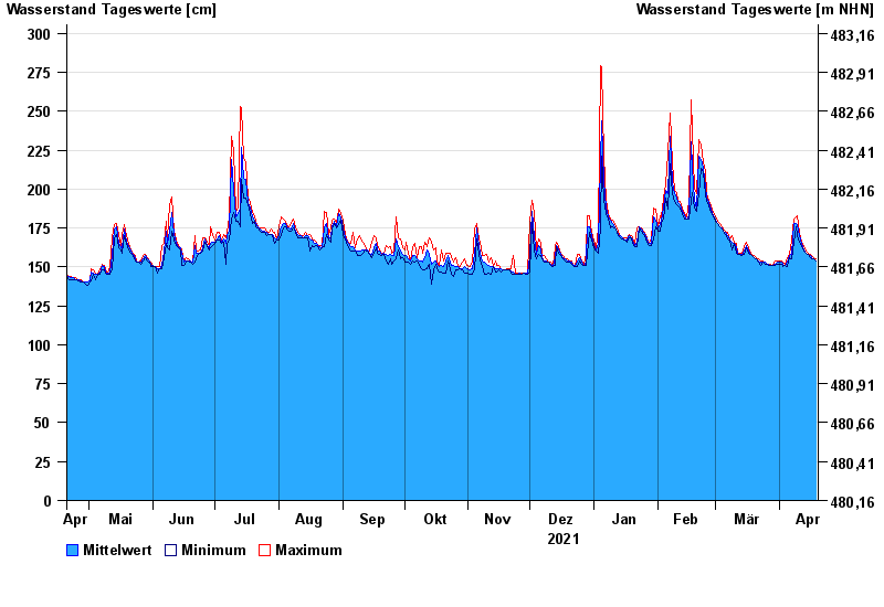
Jahresgrafik Oberkotzau / Sächsische Saale
Wasserstand vom 20.04.2021 bis zum 19.04.2022
- 01.11.1998 Wasserstand: 391 cm
- 23.01.1995 Wasserstand: 369 cm
- 06.01.1982 Wasserstand: 368 cm
- 26.02.2002 Wasserstand: 360 cm
- 14.01.2011 Wasserstand: 354 cm
| Datum | Mittelwert [cm] | Maximum [cm] | Minimum [cm] |
|---|---|---|---|
| 19.04.2022 | 154 | 155 | 154 |
| 18.04.2022 | 155 | 156 | 155 |
| 17.04.2022 | 156 | 157 | 155 |
| 16.04.2022 | 157 | 158 | 156 |
| 15.04.2022 | 158 | 159 | 158 |
| 14.04.2022 | 159 | 160 | 159 |
| 13.04.2022 | 161 | 163 | 160 |
© Bayerisches Landesamt für Umwelt 2024