
- Startseite >
- Flüsse >
- Wasserstand >
- Oberer Main - Elbe >
- Kauerndorf >
- Jahresgrafik

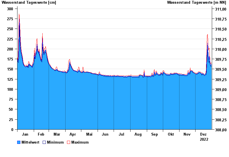
Jahresgrafik Kauerndorf / Schorgast
Wasserstand vom 01.01.2022 bis zum 31.12.2022
Hinweis
Bauarbeiten am Pegel
- 28.05.2006 Wasserstand: 341 cm
- 14.01.2011 Wasserstand: 333 cm
- 28.01.2002 Wasserstand: 326 cm
- 30.12.1986 Wasserstand: 319 cm
- 13.02.2005 Wasserstand: 317 cm
| Datum | Mittelwert [cm] | Maximum [cm] | Minimum [cm] |
|---|---|---|---|
| 31.12.2022 | 162 | 166 | 157 |
| 30.12.2022 | 159 | 162 | 156 |
| 29.12.2022 | 162 | 165 | 160 |
| 28.12.2022 | 168 | 171 | 165 |
| 27.12.2022 | 182 | 202 | 170 |
| 26.12.2022 | 173 | 201 | 166 |
| 25.12.2022 | 184 | 197 | 174 |
© Bayerisches Landesamt für Umwelt 2024