
- Startseite >
- Flüsse >
- Wasserstand >
- Oberer Main - Elbe >
- Johannisthal >
- Jahresgrafik

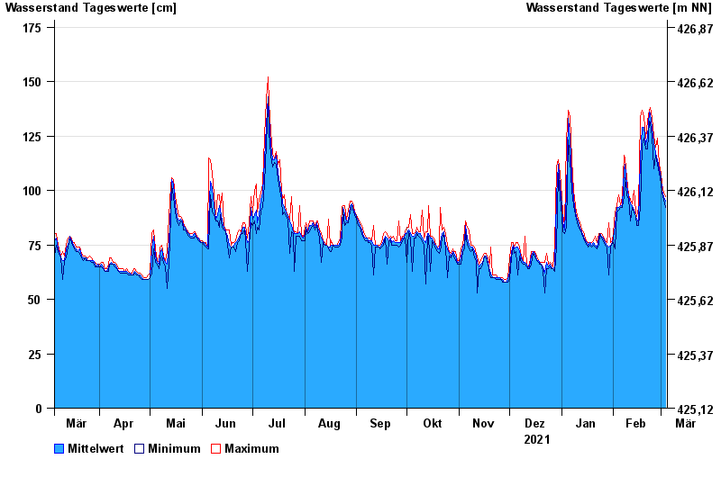
Jahresgrafik Johannisthal / Tirschenreuther Waldnaab
Wasserstand vom 05.03.2021 bis zum 04.03.2022
- 02.11.1998 Wasserstand: 221 cm
- 03.01.2003 Wasserstand: 220 cm
- 14.01.2011 Wasserstand: 214 cm
- 13.02.2005 Wasserstand: 203 cm
- 03.06.2013 Wasserstand: 202 cm
| Datum | Mittelwert [cm] | Maximum [cm] | Minimum [cm] |
|---|---|---|---|
| 04.03.2022 | 95 | 97 | 92 |
| 03.03.2022 | 97 | 99 | 96 |
| 02.03.2022 | 100 | 103 | 99 |
| 01.03.2022 | 106 | 108 | 103 |
| 28.02.2022 | 110 | 112 | 108 |
| 27.02.2022 | 114 | 124 | 112 |
| 26.02.2022 | 117 | 120 | 116 |
© Bayerisches Landesamt für Umwelt 2024