
- Startseite >
- Flüsse >
- Wasserstand >
- Oberer Main - Elbe >
- Bärenthal >
- Jahresgrafik

Jahresgrafik Bärenthal / Trubach
Wasserstand vom 11.08.2020 bis zum 10.08.2021
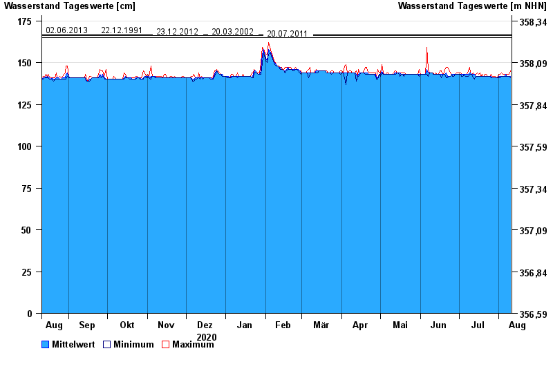
Hinweis
Absinken des Wasserstandes wegen Entfernung von Auflandungen.
- 02.06.2013 Wasserstand: 167 cm
- 22.12.1991 Wasserstand: 167 cm
- 23.12.2012 Wasserstand: 166 cm
- 20.03.2002 Wasserstand: 166 cm
- 20.07.2011 Wasserstand: 165 cm
| Datum | Mittelwert [cm] | Maximum [cm] | Minimum [cm] |
|---|---|---|---|
| 10.08.2021 | 142 | 145 | 141 |
| 09.08.2021 | 142 | 143 | 142 |
| 08.08.2021 | 142 | 143 | 142 |
| 07.08.2021 | 142 | 143 | 142 |
| 06.08.2021 | 143 | 143 | 142 |
| 05.08.2021 | 142 | 143 | 142 |
| 04.08.2021 | 142 | 143 | 142 |
© Bayerisches Landesamt für Umwelt 2024