
- Startseite >
- Flüsse >
- Wasserstand >
- Bayern >
- Rosenheim u.d. Mangfallmündung >
- Gesamtzeitraum

Gesamtzeitraum Rosenheim u.d. Mangfallmündung / Inn
Wasserstand vom 26.01.1970 bis zum 01.05.2024
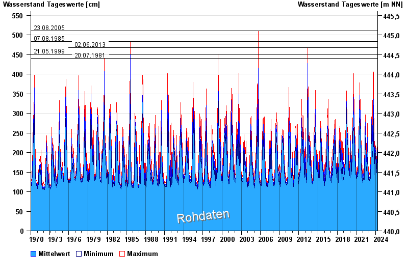
- 23.08.2005 Wasserstand: 511 cm
- 07.08.1985 Wasserstand: 483 cm
- 02.06.2013 Wasserstand: 468 cm
- 21.05.1999 Wasserstand: 451 cm
- 20.07.1981 Wasserstand: 441 cm
| Datum | Mittelwert [cm] | Maximum [cm] | Minimum [cm] |
|---|---|---|---|
| 01.05.2024 | 163 | 166 | 161 |
| 30.04.2024 | 158 | 167 | 152 |
| 29.04.2024 | 145 | 155 | 140 |
| 28.04.2024 | 144 | 157 | 133 |
| 27.04.2024 | 145 | 148 | 142 |
| 26.04.2024 | 137 | 143 | 129 |
| 25.04.2024 | 143 | 149 | 139 |
 weitere Messwerte weitere Messwerte | |||

© Bayerisches Landesamt für Umwelt 2024